Day: Wednesday, 28th September 2016
Miles: 2503 – 2532.7 (30)
Remote Site 2503.0 – Vista Creek Remote Site 2532.7
I spoken many times on this blog, about my love of the volcanic cones of the Cascade Range. We’ve come face to face with all of the giants of the Cascades on this trail, from Mount Shasta through to Mount Rainier. Its an exciting feeling, to come face to face with with an incredible mass like this. Such imposing prominence, their shadows cast to the horizon at sunset, and their steep sides cloaked in fine rock. Their past as destructive and constructive forces in the creation of this rugged landscape has always provided intrigue and interest, as the trail navigates obsidian, ancient lava flows, cinder cones and decadent views of extreme beauty. As I looked towards a day navigating the western edge of Glacier Peak, I was excited and perhaps sad. This would likely be my last volcanic encounter on this endeavor. Adding to the emotion, today was one of the largest elevation gain/loss combinations in recent memory, perhaps even on the entire trip (although the Sierra likely challenges it, but I have not compared notes).
My fellow hikers, that I shared camp with, were exuding enthusiasm and energy at an obscene hour this morning. We conversed as an impression of the sun rose over the desolate ridge east of us, the views were all but obscured by a low cloud base. After yesterday, the presumptive disappearance of this candy-floss blanket should occur some time this morning, so we did not lament the fact that Glacier Peak was nowhere to be seen, albeit just a few miles to the north. The breeze was bracing, as I tending to my morning routine, and a few extra layers were necessary. As I popped a pre-emptive Vitamin-I (Ibuprofen), I stood, stopped and listened for a moment. The color was once again vivid, even in this dull morning light. The sound of gushing water in the creek next door to camp, along with the sound of birds singing was a little magical. I was last out, and it was 7:30AM.

Waking up to some varied skies and a chilly breeze.
Immediately, the trail dropped a little and followed the beautiful creek that serenaded us last night for a few miles. It was cold and fast moving. One comment I must make about Washington – the water is always fresh, clear and tastes amazing!

Dropping down into the heart of the valley alongside a pretty creek.
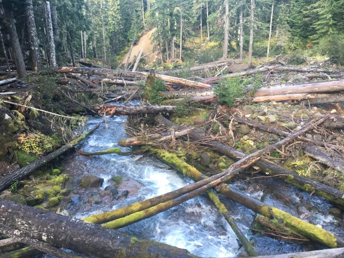
Dropping further and further down into the valley floor, and the creek gained size and speed. It energy dissipating into a series of deep ravines, strewn with enormous trees. Debris was haphazardly flung into corners like some kind of natural homage to a teenagers bedroom. The creek joined to a much larger glacial creek after a sudden and marked drop in elevation on the trail. By now, it was a milky colored torrent. Cold and unfriendly to the passing eye.

Signs of Glacial melt with the milky waters in White Chuck River.
As the creek flushed to the west, the trail then followed a drier, higher routing. This brought me through a series of amazing moss clad stands of trees. As the trees further and further obscured the light, the intense greens and fungi seemed to assert themselves more and more, until the trail seemed like a wander through a well tended arboretum.

Walking in an enchanted forest.
Passing a few more creeks, and there was obvious signs that early in the season, these rivers contain enormous amounts of power, liberally enacted on unfortunate trees, peering too close to the edge.
Obviously intense flow is an occurrence in Spring based on these debris flows.

Beautiful funghi growing amongst the thick mossy carpet in this damp valley.
Towards the lowest point in the valley, and the skies and views ahead opened out to another glorious vista of snow clad high peaks, with thick green forest in all directions. I became aware of the next high saddle the trail would ascend, and braced myself for a morning of climbing!

A long climb ahead
Almost unexpectedly, after dwelling on the climb ahead, and become preoccupied with my map and elevation chart, I stumbled onto the infamous Kennedy Creek broken bridge at mile 2509.8. I have seen images of this bridge in numerous blogs and websites, but I had presumed it was washed away years ago. Somehow it persisted in this decrepit state.

Kennedy Creek and the infamous broken bridge

Kennedy Creek
After Kennedy Creek, the trail immediately begins its climb towards the northwest quadrant of Glacier Peak. After a few switchbacks and I was awarded the view I had anticipated all morning, a sun drenched Glacier Peak to the east!

Glacier Peak
Rising higher, and views to the high peaks and beautiful valley to the west were also an enjoyable side-show to the drama filled glacial ridges on the east.

Looking to the west, and a beautiful forested valley.
With almost every turn, a new perspective of Glacier Peak was provided, sometimes from inside the treeline, then above, views up glacial-fed creek ridges and over desolate barren ridges devoid of even the stubborn vegetation. The looming mass of the giant, stationary and motionless even with the moving landscape around me.

Glacier Peak, ever looming above.
Eventually, I came to a high saddle, that represented the first high point for my morning hike. Amazing views north came into the enormous panorama before me. Up to now Glacier Peak has obscured this perspective, so this is my first proper view towards the North Cascades National Park, and the landscape that will frame my last few days on the trail. I decided to take lunch at this point. A moment to savor a 360 degree view of Washingtons finest jewels.
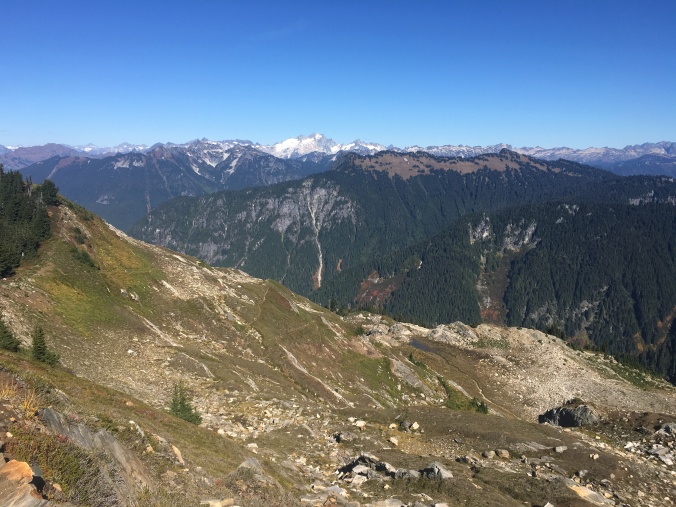
Looking north to the North Cascades National Park

A view to Glacier Peak from its northwestern side.
After conversing with some other highers, and a chat with Syrup whom I had met a few times this morning, I began the long hike down to Milk Creek. Along the way, I stopped at Mica Lake, the bluest of blue lakes shimmering in the sun. A bunch of hikers were gathered at its eastern end taking in some sun, a swim, and some lunch, arguably a better spot than I chose myself!

A good spot to chat to some other hikers for a while.
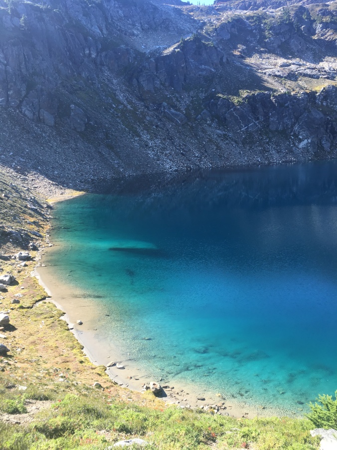
Turquoise waters were inviting, and ICE cold!
After Mica Lake, the trail then followed a grassy ridge for a time, with access to probably the best public convenience yet! Washington just keeps pushing the bar higher with a view like this from the potty!

The absolute best potty view yet!
Pushing onwards, and a daunting view of switchbacks could be seen dead ahead for a significant portion of the trail. After liaising with my trusty maps, I realized that to get to these switchbacks, would entail an elevation drop of almost 2000ft followed by a gain of 2000ft in order to navigate the Milk River at its bridge crossing and return to the traverse around the north side of Glacier Peak. Thankfully (sarc), as I dropped into the shadow on the ascent, I enjoyed some pretty views of the trail I would be ascending in two hours time’!

In reality, the view of the ascent was far worse than the actual ascent. By the time I was working my way back up the switchbacks, the evening glow on the landscape and the peak ahead, had transformed it into something completely new. The softer hues on the landscape and the alpenglow gradually building on the glaciers ahead were simply magnificent.

Finally pushing through the final switchbacks, and the following ridge once again opened into something completely new, a sheltered series of enormous meadows sporadically populated here and there with stubby evergreen trees. I hastened my pace, such that I could get back into the sun-line as by now, the sunset was established, with a noticeable chill at these elevations.

After a quick chat with a senior hiker laying out camp for the night on a high ridge with a commanding view near the former Dolly Vista Shelter, I was now about to embark on another large elevation drop, from 5700ft down to the 2300ft and the Suiattle River. As if to give me one last gift from the Cascade volcanoes before my descent off the flanks of Glacier Peak, as I took in my last view of the great expanse to the north from this ridge-line, another silhouette appeared in the northwestern sky, none other than Mt.Baker, the last and (for me) most illusive of the Cascade volcanoes!

A distant silhouette of Mt.Baker sneaks into view for a short time.
The descent towards tonights target was a slow steady progress. I had been playing with the idea of stopping short of the Suiattle River given how quickly nightfall had dropped in. Also, I was aware that a large stand of old growth forest existed just before the river crossing. It seemed like a shame to rush past in the middle of the night. I viewed the looming giant above, its glaciers glinting in the night for the last time as the trail dropped into heavy growth forest.

As I descended further, I came against a large number of fallen trees in addition to the slippy trail and worn out trail tread in many places. As with my day of troublesome fallen-tree navigation in Oregon, this started to become tiring and tedious. Some of the trees were enormous giants of the forest, and in one case, the only way to get around it, was to throw my pack underneath and crawl through a tiny space between the ground and the tree trunk.

Crawling beneath tree trunks in the dark. What fun!
I finally reached one of the first flat areas beyond the descent late in the evening, only to find that it was already filled with a large number of hikers packed into the tiniest of areas. I was tired and not inclined to go further, when I heard a friendly voice, a realized that Breakaway and FlyBy were camped here. There was a small spot beside a broken up tree trunk that I figured I could make my own, and set up camp quietly. Everyone seemed to be in bed or cooking their dinner, so I settled into the same routine, and looked forward to hiking tomorrow with my old crew again! Sprinkles, Homegrown, Blue and S’rocket at this point were most likely camped somewhere behind. Given the long day and elevation gain, I was surprised at the mileage I completed. It was a very fulfilling day!

You’ve got great writing skills. Can’t wait
To do this section later this summer. I’ll be at Mica Lake for the eclipse…at least 90% of it.
-GoalTech
LikeLike